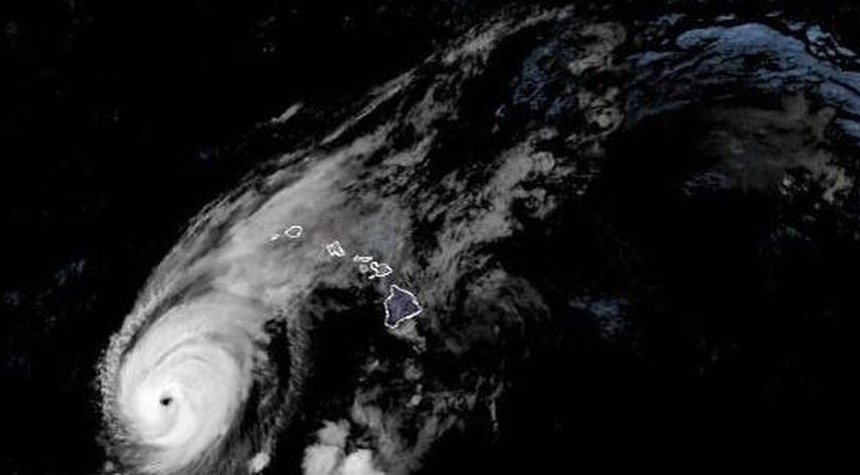
Hurricane Lowell, a formidable Category 3 storm packing sustained winds of 115 miles per hour, advanced toward western Hawaii early Monday, prompting emergency officials to issue a hurricane warning for the islands of Kauai and Niihau. The National Hurricane Center in Miami has also placed the island of Oahu under a tropical storm watch as the dangerous system continues its northward trajectory.
The hurricane warning encompasses not only the populated islands but extends into portions of the Papahanaumokuakea Marine National Monument, one of the world’s largest marine conservation areas, spanning nearly 583,000 square miles of ocean and including ten of Hawaii’s northwestern islands. Meteorologists project that Lowell will traverse sections of this protected area as it moves past the island chain.
According to current forecasts, the storm’s center is expected to pass just west of the main Hawaiian Islands, in the vicinity of Niihau, late Monday night. The system is then anticipated to decelerate considerably by early Wednesday after clearing the islands. The hurricane center has indicated that while gradual weakening is forecast through Tuesday, Lowell is expected to maintain hurricane strength as it passes near the Hawaiian archipelago.
Hurricane-force winds currently extend outward up to 60 miles from the storm’s eye, presenting a substantial threat to maritime interests and coastal areas alike.
The rainfall predictions are particularly concerning. Forecasters estimate that Kauai could receive between six and ten inches of precipitation, with isolated areas potentially seeing as much as sixteen inches. The Big Island faces projections of four to eight inches, with maximum amounts reaching twelve inches in certain locations. Meanwhile, Oahu and Maui County could experience four to eight inches, with up to ten inches possible depending on precise storm track and local topography.
The National Hurricane Center has warned that these rainfall totals could produce significant flash flooding and mudslides, particularly across Kauai County and portions of Hawaii’s Big Island, where mountainous terrain amplifies runoff dangers.
Storm surge presents an additional threat. Kauai County could experience water levels rising as much as four feet above normal tide levels, while Oahu faces the prospect of up to one foot of surge. The center has also cautioned that life-threatening surf conditions and dangerous rip currents will affect many of the Hawaiian islands throughout the storm’s passage.
In a less common but notable threat for Hawaii, atmospheric conditions associated with Lowell could spawn several tornadoes near Kauai and Niihau Monday afternoon through Monday night. Additional tornadoes remain possible across other parts of the state, though with lower probability.
State and local emergency management officials are coordinating response efforts as residents secure property and stock emergency supplies. The approach of Hurricane Lowell serves as a reminder that while Hawaii’s geographic isolation in the central Pacific typically shields it from the worst tropical cyclone activity, the islands remain vulnerable when storms track into the region during the hurricane season.
Related: Ex-Governor Pataki Joins Thousands Suffering Long-Term Effects of 9/11 Toxic Exposure